|
|
|
- Home
- Forecast
- Severe Weather Outlook
- Satellite
- Maps
- Graphs
- Gauges
- Reports
- History
- Links
- About
- Site Map
- Mason MI
LIBERTY FAIRFIELD WEATHER CENTER |
Liberty Township / Fairfield Township (Butler County) - Hamilton, Ohio, U.S.A. |
Now: 75°F at 7:06pm 8/2/26 |
|||||
Feels Like: 78°F |
|||||
| Tonight Chance T-storms then Partly Cloudy |
Monday Partly Sunny |
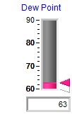
- Comfort Index -
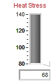
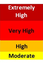
- Heat Stress Index - |
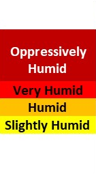
- Humidity Index -
- Frostbite Time - |
Record High
98°F
Record Low 50°F
|
|||
| Lo 63 °F | Hi 81 °F | Sunrise: 6:40am | Sunset: 8:51pm | Normals: 86° / 64° |
| ||||||||||||||||||
|
| Forecast: Tonight through Monday Night |
|
Sunrise: 6:40am Sunset: 8:51pm
|
| National Weather Service Local Forecast issued at 4:00 pm EDT Aug 2, 2026 |
| Tonight Chance T-storms then Partly Cloudy |
Lo 63 °F A chance of showers and thunderstorms before 8pm. Partly cloudy, with a low around 63. North wind around 7 mph. Chance of precipitation is 40%. New precipitation amounts of less than a tenth of an inch, except higher amounts possible in thunderstorms. |
Monday Partly Sunny |
Hi 81 °F Partly sunny, with a high near 81. North wind around 8 mph. |
Monday Night  Mostly Clear |
Lo 58 °F Mostly clear, with a low around 58. North wind around 6 mph becoming calm after midnight. |
|||||||
| 7 DAY HOURLY FORECAST TABLES & GRAPHS | ||||||||||||
| 48 Hour Temperature Forecast |
||||||||||||
| 48 Hour Precipitation Potential Forecast |
||||||||||||
| Select Graph for Full Forecast | ||||||||||||
S E V E R E W E A T H E R I N F O R M A T I O N
|
||
- Indy Radar -
|
- Current Weather Statements -
|
- Severe Weather Outlook -
|

|

|
 - National Weather Service Data Feeds - Wilmington, OH Weather Statements Indianapolis, IN Weather Statements Louisville, KY Weather Statements |
|
|||||||||
|
|
 |
- Current Sermon Series -
First Things: What Christians Really Believe
|
Recent Sermon Series:
1 John: The Word of Life
Jude: Contending for the Faith
|
|
|
|
||||||||||||||||||||||||||||||||||||||||||||
|
|
|||||||||||||||||||||||||||||||||||||||||||||


W E A T H E R A L M A N A C
|
||||||||
- T O D A Y -
|
- Y E S T E R D A Y -
|
|||||||
Since
Midnight |
Record
Coldest |
Normal
|
Record
Warmest |
Temperature
Yesterday |
Record
Coldest |
Normal
|
Record
Warmest |
|
High Temperature
|
82.1°
|
66°
|
86.8°
|
98°
|
82.9°
|
75°
|
86.8°
|
98°
|
Mean Temperature
|
75.2°
|
-
|
75.5°
|
-
|
76.1°
|
-
|
75.5°
|
-
|
Low Temperature
|
68.2°
|
50°
|
64.3°
|
79°
|
69.3°
|
52°
|
64.3°
|
77°
|
Daily Precipitation
|
0.01"
|
Record Rain
2.68" |
Record Snow
0.0" |
2.07"
|
Record Rain
2.03" |
Record Snow
0.0" |
||
| * "Normals" are 30 Year Average values at the Butler County Regional Airport (3.2 miles to the southwest). "Records" are at Cincinnati, Ohio. (25 miles to the south-southwest). |
S U M M A R Y F O R Y E S T E R D A Y
|
|||
|
| * "Normals" are 30 Year Average values at the Butler County Regional Airport (3.2 miles to our southwest). "Records" are at Cincinnati, Ohio. (25 miles to our south-southwest). |
M I S C E L L A N E O U S I N F O R M A T I O N |
|||||
Hourly Rainper Acre |
Daily Rainper Acre |
24 Hour Rainper Acre |
Yesterday's Rainper Acre |
Monthly Rainper Acre |
Annual Rainper Acre |
WaterBoiling Point |
Current Rainfall Rateper Acre |
DensityAltitude |
PressureAltitude |
VaporPressure |
VirtualTemperature |
° |
feet |
feet |
" Hg |
° |
|
D a v i s V a n t a g e P R O 2 - W E A T H E R S T A T I O N G E N E R A T E D F O R E C A S T
|
| (Updated Hourly) |
| The Davis Vantage PRO 2 Weather Station uses a sophisticated forecasting algorithm which takes into account Barometric Pressure, Wind, Rainfall, Temperature, Humidity, Latitude and Longitude. "The result is a much more accurate forecast. Not perfect, but much better than many other Personal Weather Stations". |
| Additional Weather News and Links |
|
Local Interactive Weather Map
EF1 Tornado in Liberty Township May 26th, 2011 |
| Weather Data from this station is contributed to the following organizations: |
Station ID: DW1039 |
 Community Collaborative Rain, Hail & Snow Network
Station ID: OH-BT-1 |
 Weather For You / PWS
Station ID: DW1039 |
 Midwestern Weather Network
 Weather Underground
Station ID: KOHHAMIL7

Never base important decisions on this or any weather information obtained from the Internet
Updated Automatically by Ambient Weather's Virtual Weather Station
Data Collected using a Davis Vantage Pro2 Weather Station
Weather Advisory & Forecast Scripts courtesy of saratoga-weather.org