| www.lfweathercenter.com |
|
- Home
- Forecast
- Severe Outlook
- Satellite
- Maps
- Graphs
- Gauges
- Reports
- History
- Links
- About
- Site Map
- Mason MI
Aurelius Township - Ingham County - Michigan - U.S.A.
|
Nearby METAR Reports
Metar display script from Saratoga-Weather.org | ||||||||||||||||||||||||||||||||||||||||||||||


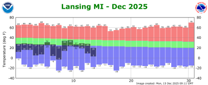
| - Nearby Personal Weather Station - Columbia Lakes Mason Jewet Field Airport 72 Hour Observation History Lansing Year To Date Climate Plot Lansing Current Month Climate Plot | ||||||||||||||||||||||||||||||||||||||||||||||||||||||||||||||||||||||||||||||||||||||||||||||||||||||||||||||||||||||||||||||||||||||||||||||||||||||||
|
| ||||||||||||||||||||||||||||||||||||||||||||||||||||||||||||||||||||||||||||||||||||||||||||||||||||||||||||||||||||||||||||||||||||||||||||||||||||||||
National Weather Service Forecast |
Aurelius Township, Michigan, U.S.A. |
| Forecast issued at 7:06 am EDT Aug 3, 2026 by the National Weather Service Grand Rapids, MI |
Area Forecast Discussion National Weather Service Grand Rapids MI 645 AM EDT Mon Aug 3 2026 .KEY MESSAGES... - Mostly Sunny into Tuesday - Showers and Thunderstorms Possible Tuesday Night into Friday |
| 4 D A Y F O R E C A S T A T A G L A N C E | ||||||||||||||||||||||||||||||||||||||||||||||||||||||||||
|
||||||||||||||||||||||||||||||||||||||||||||||||||||||||||


|
| NATIONAL WEATHER SERVICE - WINTER WEATHER FORECASTS | |
48 Hour Temperature and Dew Point Forecast DEW POINT: 60-64=Slightly Humid, 65-69=Humid, 70-74=Very Humid, 75-79=Oppressively Humid, Greater than 79=Very Oppressively Humid |
|
48 Hour Precipitation Potential and Sky Cover Forecast |
|
48 Hour Rain and Thunder Forecast |
|
48 Hour Snow Freezing Rain and Sleet Forecast |
|
48 Hour Wind Forecast |
|
| 7 DAY HOURLY FORECAST TABLES & GRAPHS |
| Today through Sunday | ||||||||||||||||||||||||||||||||||||||||||||||||||||||||||||||||||||||||||||||||||||||||||||||||||||||||||||||||||||||||||||||||||||||||||||||||||||||||
|
||||||||||||||||||||||||||||||||||||||||||||||||||||||||||||||||||||||||||||||||||||||||||||||||||||||||||||||||||||||||||||||||||||||||||||||||||||||||
|
||||||||||||||||||||||||||||||||||||||||||||||||||||||||||||||||||||||||||||||||||||||||||||||||||||||||||||||||||||||||||||||||||||||||||||||||||||||||
| S E V E R E W E A T H E R I N F O R M A T I O N | ||
- Grand Rapids, Michigan Radar -
|
- Current Weather Statements -
|
- Severe Weather Outlook -
|

| 
|
 - National Weather Service Data Feeds - Grand Rapids, MI Weather Statements Northern Indiana Weather Statements |
| Midwest Satellite |

|
| Day 1 Precipitation Quantity Forecast |

|
| Day 1 Excessive Rainfall Forecast |

|
| Day 1 Probability of at least 4 inches of Snow |

|
| Advisories to the south |

|
Never base important decisions on this or
any weather information obtained from the Internet
Weather Advisory & NWS Forecast
PHP Scripts courtesy of saratoga-weather.org